


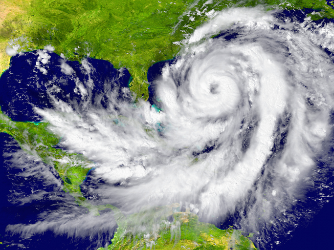
Andrew had the ferocity of a tornado but was nearly twice the size of Delaware. It clawed roofs off houses, ground neighborhoods to sticks, split palm trees with plywood, and threw boats into Biscayne Bay, but only 15 people were killed in the initial mauling. The storm passed through South Florida in less than four hours, but its survivors were forever changed.
In the months and years following its landfall on August 24, 1992, Hurricane Andrew was dubbed the “Big One.” It was upgraded to Cat 5 status in a 2002 reanalysis, with top wind speeds of 165 mph at the coast, and it lives in infamy for the devastation it caused.
“We watched the central pressure drop and drop and drop,” said Richard Pasch, a National Hurricane Center Specialist who was on the team forecasting Andrew 30 years ago when gales ripped the radar from the roof of the center’s Coral Gables office. “It was without a doubt one of the worst storms.” It was the worst for many people.”
Since Andrew, there have been larger, faster, and wetter hurricanes. Whereas Andrew’s hurricane-force winds spread 30 to 45 miles from its center, Irma’s destructive reach was 80 miles. On October 24, 2005, Wilma’s hurricane-force winds extended 90 miles from its center as it approached Cape Romano.
The question of whether a recent spate of Cat 5 storms — six since 2016 — and soggy lesser storms that were no less destructive can be directly attributed to a warming world is still being debated, with scientists wary of blaming individual events on climate change.
New research suggests that a feverish Earth may reduce hurricane fecundity by, in part, producing more shredding wind shear, which kills storms in their infancy.
Six years of above-normal tropical cyclone activity have been aided by super satellites seeing what was unimaginable 60 years ago. When the National Hurricane Center began naming subtropical cyclones in 2002, the number of named storms increased as well.
Nonetheless, many experts agree that warmer waters mean more fuel for storms that do form, as well as more bouts of rapid intensification. Higher sea levels bring more storm surge inland. Furthermore, some climate models dating back before civilization have indicated a slowing of the Gulf Stream current, which could result in a larger pool of high-octane water on Florida’s doorstep.
“There is no doubt that research indicates that we are seeing more intense hurricanes,” said Jo Muller, a paleoclimatologist and associate professor at Florida Gulf Coast University’s Water School. “When you have really warm sea surface temperatures, like Hurricane Michael, you can go from a strong Cat 2 to a Cat 5 in a day, which is terrifying.”
Storms gain energy as sea surface temperatures rise.
Hurricane Michael, which slammed into Mexico Beach in Florida’s Panhandle as a Category 5 storm in 2018, was one of several that were influenced by a trip over the Gulf of Mexico’s deeply warm loop current or one of its eddies.
Hurricanes Katrina and Rita passed through the same loop current about three weeks apart in 2005, both intensifying to Cat 5 storms. Hurricanes Isidore, a Category 3 in 2002, and Gustave and Ike, both Cat 4s in 2008, were also fueled by the simmering fast-moving current.
Hurricane Andrew accelerated as it crossed the Gulf Stream current and closed in on Fender Point, eight nautical miles east-northeast of Homestead. It had also gone through an eyewall replacement cycle, in which thunderstorms circling the center of the storm uncoil and are replaced by tighter, stronger storms.
The Miami radar failed at 4:35 a.m., having been blown off the roof of the National Hurricane Center. Andrew made landfall at 5:05 a.m.
“I’ve never seen anything like Andrew that wasn’t a powerful tornado,” Bryan Norcross, a Miami-based TV meteorologist at the time, said. “Neighborhood after neighborhood after neighborhood after neighborhood was destroyed.”
Norcross is well-known for advising people to seek shelter from the storm in their bathtubs with a mattress over their heads. In a July interview, he described his advice as “intuitive and spontaneous.”
“I’m not sure how many people did that and lived through their house falling apart,” he explained. “All they could see when it was over was sky.”
Over 25,000 homes were destroyed. Over 100,000 houses were damaged. According to the National Hurricane Center’s reanalysis of Andrew, farmers suffered crop losses totaling more than $1 billion.
“Andrew changed everything for the state of Florida,” said Erik Salna, associate director of education and outreach at Florida International University’s Extreme Events Institute. “It jolted us awake. It changed building codes and emergency management preparedness, propelling us to the forefront of storm response.”
After Andrew, FIU established the International Hurricane Research Center. The center, which is now part of the Extreme Events Institute, was responsible for the creation of the Wall of Wind. The 12-fan beast can generate winds of up to 160 mph.
A new program aims to simulate winds of up to 200 mph.
“We have to go 200 mph because that’s where Mother Nature is going,” Salna explained.
How the melting Greenland ice sheet could provide food for hungry hurricanes
Melting ice at the poles could mean a wider, deeper feeding trough for Atlantic basin hurricanes off Florida’s east coast thirty years after Andrew.
According to an increasing number of studies, freshwater from thawing glaciers is slowing a critical Atlantic Ocean circulatory pattern that includes the Gulf Stream current. The circulation is a massive cooling system for the planet, transporting hot water from the tropics to the north on a massive conveyor belt.
Salinity and temperature are the mechanisms that drive circulation. As the current moves north along the East Coast of the United States, it begins to cool. The salty, cool water near Greenland is dense enough to sink and swing back south across the equator into the Southern Hemisphere.
Too much freshwater from ice melt can dilute the saltiness, making it less dense, causing it to dive deeper and slower.
The problem is that there hasn’t been much evidence to back up the slowdown in actual observations, according to Lisa Beal, an ocean sciences professor at the Rosenstiel School of Marine and Atmospheric Science.
“In terms of what we know about climate change, the ocean is the weak link,” she said.
Reliable measurements of the Gulf Stream have been taken for about 35 years and do not “robustly” show any weakening, according to Beal, who agrees that historical modeling does show a slowdown.
A slower Gulf Stream would result in higher sea levels along the east coast as warm water accumulates and expands.
“The Gulf Stream is one of the major factors that affect sea level in Florida,” Muller explained.
Storm surge may become more powerful and higher as sea levels rise.
Brian Soden, an atmospheric science professor at the University of Miami, has developed models that simulate a Hurricane Andrew-like storm at various sea level heights.
The Atlantic Coastal Ridge, which rises to 40 feet in some places and spans 12 miles south-southwest of Miami, shielded inland areas from Andrew’s saltwater push in 1992.
Andrew’s surge was 4 to 6 feet high in northern Biscayne Bay at high tide. It reached a height of 16.9 feet at the Burger King International Headquarters on the bay’s western shoreline.
With 3 feet of sea level rise, another Andrew would overtop the protective ridge of shelly sand, coquina, and limestone, according to Soden.
“It’s not an immediate threat,” Soden said of the 3-foot rise in sea level. “That is not going to happen until the end of the century.”
Another issue with climate change is that warmer air can hold more water vapor, resulting in heavier rain. When the land is unable to drain, this, combined with sea level rise, can increase the risk of flooding.
In some areas of southeast Florida, Andrew dumped up to 7 inches of rain. Although it was enough to cause some local flooding, Andrew was deemed a mostly dry storm.
Tropical cyclone rainfall rates are expected to increase by 10% to 15% within 60 miles of a storm as temperatures rise by 2 degrees Celsius, or 3.6 degrees Fahrenheit. According to a July revision to a National Oceanic and Atmospheric Administration review of global warming and tropical cyclone research. For comparison, the Paris Climate Agreement seeks to limit global temperature rise this century to less than 2 degrees Celsius above pre-industrial levels.
The NOAA report makes no mention of the Gulf Stream current, and Soden is less convinced of the Gulf Stream’s influence on future hurricanes. He stated that the most audacious evidence of tropical cyclone links to climate change is sea level rise and flooding rainfall.
In some areas of Texas, Hurricane Harvey dumped more than 5 feet of rain in 2017. During Hurricane Florence in 2018, North Carolina received up to 3 feet of rain.
“All else being equal,” said Jerry F. McManus, professor and chairman of Columbia University’s Department of Earth and Environmental Sciences. “However, not everything is equal, and a warm ocean isn’t the only requirement for a hurricane to form.”
Andrew wreaked havoc on South Florida, but there had been worse before and after.
There had been stronger storms before Andrew, which had sustained winds of 175 mph at its peak.
The Great Labor Day Hurricane of 1935 hit the Florida Keys with winds of 185 mph. Hurricane Allen hit Texas as a Category 3 storm in 1980, with winds of 190 mph. Camille made landfall near Waveland, Mississippi, in 1969, with winds of 175 mph.
Prior to 2016, the Atlantic basin had gone eight years without a Cat 5 hurricane.
Before Hurricane Andrew, there hadn’t been a landfalling hurricane in South Florida since 1964’s Isbell, which hit near Everglades City. In 1979, Hurricane David swept up the east coast from Stuart to Daytona Beach. In 1987, Floyd strafed Key Largo.
“It was a different mindset back then than it is now with all the anticipation and nervousness,” Norcross said, noting that there were no social media or weather apps available when Andrew was on its way to Florida. “Because everyone was watching TV, it was easier to communicate with people.” You now have ten or more different sources.”
The National Weather Service’s Miami office did not have a warning coordination meteorologist, as it does today. Doppler technology was new to weather service offices and hadn’t yet been installed at the hurricane center. Andrew’s deathblow to the old radar hastened its replacement.
Salna worked as an on-air meteorologist for the Fort Myers NBC affiliate. Following Andrew’s landfall, news reports from Miami suggested that South Florida had escaped unscathed. However, news crews had not yet arrived in Homestead.
“I’ll never forget when the AP newswire came up with just one line: “Homestead Air Force Base is gone,” Salna said.
Andrew divides his life now at FOX Weather, according to Norcross, a bookmark of a world before and after the storm. He imagines most people who lived through it and the chaos that followed feel the same way.
“When I hear reporters say that it will take months to clean up after a storm like Michael, I think, no, it will take years,” Norcross said. “No one wants to talk about what life was like for the two years following Andrew because it was terrible.”